 About the Land

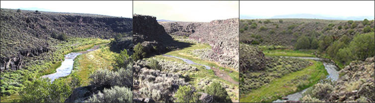
The Riverbend Subdivision is Taos’ first residential land subdivision to include a sixteen acre Conservation Easement on the Rio Pueblo de Taos. The Rio Pueblo is the most prominent tributary of the Rio Grande in the near Taos Valley area.The Rio Pueblo originates high in the mountains, runs through the Pueblo of Taos, meanders through miles of scenic countryside, through the Riverbend Subdivision and shortly thereafter joins the Rio Grande.
Prior to the Spanish occupying the land that we now call the Riverbend, the natives from Taos Pueblo and other tribes hunted and fished the Rio Pueblo. Individual bands of natives looked over into the river from the cliffs above to spot game animals. In the river corridor they left writings that are called petroglyphs. On the overlooking cliff areas they left arrowheads and some pottery shards that make up some of the archeological sites on the property. The Riverbend is a small part of a larger area of land that was formally given to early Spanish settlers as the Gijosa Land Grant. Around 1908 the Gijosa Land Grant was purchased and subdivided into forty acre tracts. The subdivision was named the Ranchos Orchard and Land Company Subdivision. . Part of the original dream of Ranchos Orchard was to establish irrigated orchards. The apple orchards were to be irrigated from a ditch that was constructed for that purpose. Remnants of the old ditch can still be seen. It ran for many miles to the southwest from northeast through the Grant. The ditch itself shows on the recorded plat for the Ranchos Orchard and Land Company.
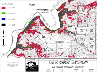
The initial offering includes sixteen tracts from 3.00 to 7.57 acres. (click to view Lot Map pdf) All of the Lots include access to the Conservation Easement which meanders along the Rio Pueblo Riparian Area for a mile. The Subdivision’s western border, which is the middle of the Rio Pueblo is bounded by the historic Pueblo of Taos.
The Riverbend Subdivision is the first development of its kind in Taos. It was designed with a conscious respect for the fragile high desert environment of the home sites that is inexorably joined with the river ecosystem of the Rio Pueblo. All of the Lots were designed to enhance the varied topography of the overall land tract. (Click to view Topography Map pdf file) The Lots were configured to take advantage of the three major drainage basins that flow through the Subdivision. Arroyos form at least one boundary of five of the Lots within the Riverbend Subdivision. The building envelopes are located 75’ away from the arroyo edges.
In addition to the Conservation Easement, (Click to view Conservation Easement Survey pdf file) the developer has restricted the riverfront Lots within the Subdivision and the prior sales within the original overall tract by mandating a one hundred foot building setback east from the Conservation Easement boundary. As part of the Taos County Subdivision approval process the developer located significant archeological sites which were identified and mapped. To ensure their continued integrity they are noted on the Subdivision Plat. (Click to view Archeological Site Map pdf file and Petroglyph Panels).
The Riverbend is located 8 miles by road southwest of the Town of Taos. (Click to view an Area Map). The elevation of the Riverbend is 6640 feet near the outflow from the downstream arroyo. Its highest point is 6754 feet at the southeast corner of the Subdivision. The northern two borders of the Subdivision are 6708 feet. (Click to view an Aerial Map of the Riverbend, a pdf file). The Town of Taos is 6950 feet and the base area at Taos Ski Valley is 9207 feet. (Click to view the land from Google Maps.)
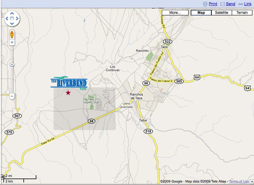 Top, Taos, with Riverbend area highlighted.
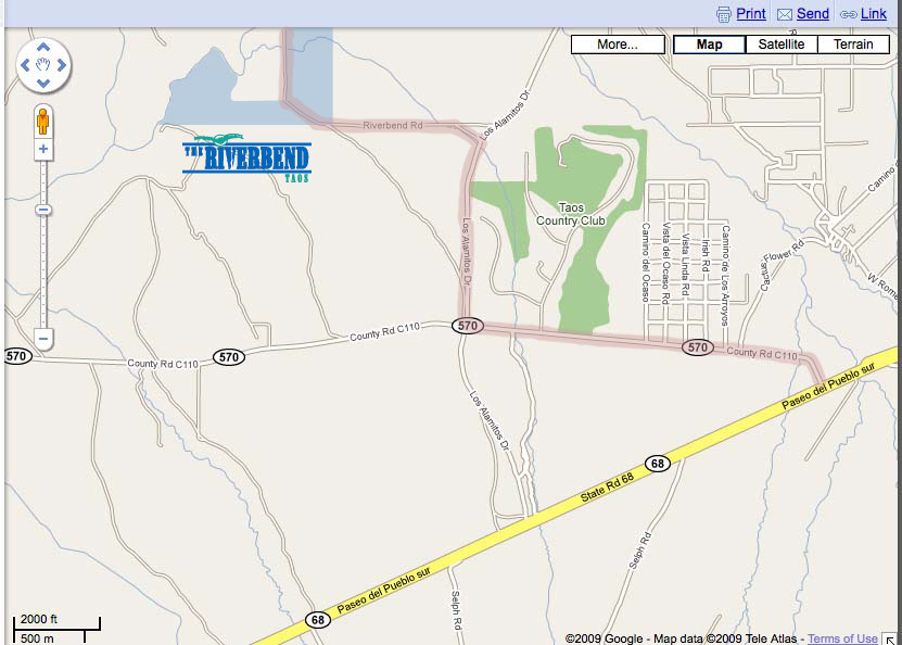
Click maps for PDF file enlargements or click here to go to Google Maps.
Bottom, detail of Riverbend vicinity. From NM Hwy 68, turn west on County Road 110 (old 570). After Taos Country Club, turn right on Los Cordovas Road. Proceed 3/4 mile to Anadarko Road. Turn left on Anadarko Rd. and drive 3/4 mile and you will be there!
- Property developed by Riverbend LLC
- Ted Terry, owner/broker
- ted@riverbendtaos.com
- 575.770.0655
- EXIT Enchanted Realty
- 7276 State Hwy 518, Ranchos de Taos, NM 87557
- 575.751.0013